Little River News

Major Flooding for Little River in SW Arkansas and SE Oklahoma

Record flooding of tens of thousands of acres throughout much of Little River and Sevier counties of Arkansas.

Serious flooding of several thousands of acres of grazing and farming land will take place. The Kansas City Southern Railroad bed will be flooded both northwest and southeast of the Highway 41 bridge. Several secondary roadways will be cutoff in the area. Also expect severe backwater flooding on the Cossatot and Rolling Fork Rivers at and upstream from their confluences with the Little River.

The golf course west of Horatio, Arkansas floods. Also, ranchers should evacuate cattle and farm machinery to higher ground and have preparations complete for a major flood. Expect considerable lowland flooding of several hundred acres of grazing and farming land. Expect major backwater flooding of small tributaries at their confluence with the Little River such as the Cossatot and the Rolling Fork Rivers.

The boat ramp recreation area at Wilton, Arkansas downstream from Horatio is flooded and closed. Also, the golf course west of Horatio, Arkansas suffers from overflow.

The golf course west of Horatio is cut off from vehicle traffic by floodwaters. A few hundred acres of lowland flood both upstream and downstream from the Highway 41 bridge.

...The Flood Warning is extended for the following river in
Oklahoma...Arkansas...

  Little River Near Idabel affecting McCurtain, Sevier and Little
  River Counties.

...The Flood Warning continues for the following river in Oklahoma...
Arkansas...

  Little River At Horatio affecting McCurtain, Sevier, Little River
  and Howard Counties.

PRECAUTIONARY/PREPAREDNESS ACTIONS...

Do not drive cars through flooded areas.
Caution is urged when walking near riverbanks.
A Flood Warning means that flooding is imminent or occurring. All
interested parties should take necessary precautions immediately.

Turn around, don`t drown when encountering flooded roads. Most flood
deaths occur in vehicles.


917 AM CDT Wed Jun 9 2021

...The Flood Warning is now in effect until Friday afternoon...

The Flood Warning continues for
  the Little River Near Idabel.
* Until Friday afternoon.
* At 8:30 AM CDT Wednesday the stage was 35.2 feet.
* Flood stage is 30 feet.
* Major flooding is occurring and major flooding is forecast.
* Recent Activity...The maximum river stage in the 24 hours ending
  at 8:30 AM CDT Wednesday was 35.3 feet.
* Forecast...The river is expected to fall below flood stage late
  Thursday evening and continue falling to 14.3 feet Monday morning.
* Impact...At 34 feet, Farmers and ranchers should have preparations
  completed for a major flood with all cattle and farm machinery
  evacuated. Thousands of acres of lowland in the Little River flood
  plain will be flooded and several secondary roads and bridges will
  be cut off.  Move livestock and equipment to higher ground.

Nursing Assistant Training Program at UA Cossatot in Nashville Beginning in July

Nursing Assistant Program

This 90-hour training combines classroom instruction, lab activities, and supervised practical training in a nursing facility. It prepares students for all aspects of nursing assisting. Successful completers receive a certificate, and are eligible to take the State competency exam. $691 (includes $645 tuition plus $46 for textbooks)  

Register by: July 7

Date: July 15 – August 12 (Mondays  - Thursdays)

Time: 8:00 AM - 2:30 PM

Location: Nashville

Instructor: Melba Hess


16 hours of clinical training will be conducted in a long term care facility within the UA Cossatot service area.

Nursing Assistant Training Program Application Packet

Flood Warning for Little River at Horatio, Flash Flood Watch and Warning in Effect for SW Arkansas

Excessive Rainfall Briefing
Flash Flood Warning for SW Arkansas and SE Oklahoma

Flash Flood Warning for SW Arkansas and SE Oklahoma

Flood Warning for Little River at Horatio

Issued By Shreveport - LA, US, National Weather Service

Affected Area: Sevier County

Description

The National Weather Service in Shreveport has issued a Flood Warning for the Little River At Horatio. From Tuesday morning to late Saturday night. At 8:00 PM CDT Monday the stage was 22.2 feet. Flood stage is 27 feet. Moderate flooding is forecast. Forecast...The Little river at Horatio is expected to rise above flood stage late tomorrow morning to a crest of 29.6 feet Wednesday evening. It will then fall below flood stage late Saturday morning. Impact...At 30.0 feet, The golf course west of Horatio, Arkansas floods. Also ranchers should evacuate cattle and farm machinery to higher ground and have preparations complete for a major flood. Expect considerable lowland flooding of several hundred acres of grazing and farming land. Expect major backwater flooding of small tributaries at their confluence with the Little River such as the Cossatot and the Rolling Fork Rivers.

More Information

...The National Weather Service in Shreveport LA has issued a Flood Warning for the following rivers in Oklahoma...Arkansas...

Little River Near Idabel affecting McCurtain, Sevier and Little River Counties.

Little River At Horatio affecting McCurtain, Sevier, Little River and Howard Counties.

PRECAUTIONARY/PREPAREDNESS ACTIONS...

Do not drive cars through flooded areas. Caution is urged when walking near riverbanks. Turn around, don't drown when encountering flooded roads. Most flood deaths occur in vehicles.

For more hydrologic information, copy and paste the following website address into your favorite web browser URL bar: water.weather.gov/ahps2/index.php?wfo=shv

 
The National Weather Service in Shreveport has issued a

* Flash Flood Warning for...
  Howard County in southwestern Arkansas...
  Northern Little River County in southwestern Arkansas...
  Sevier County in southwestern Arkansas...

* Until 145 PM CDT.

* At 940 AM CDT, Doppler radar indicated thunderstorms producing
  heavy rain across the warned area. Between 1 and 2 inches of rain
  have fallen. Flash flooding is ongoing or expected to begin
  shortly.

  HAZARD...Life threatening flash flooding. Thunderstorms
           producing flash flooding.

  SOURCE...Doppler radar.

  IMPACT...Life threatening flash flooding of creeks and streams,
           urban areas, highways, streets and underpasses.

* Some locations that will experience flash flooding include...
  Nashville, Mineral Springs, Dierks, Horatio, Umpire, Lockesburg,
  Wilton, Tollette, Winthrop, Gillham, Ben Lomond, Corinth, Center
  Point, Saratoga, Athens, Arkinda, Oak Grove, Silver Ridge, Provo
  and Bellview.

Additional rainfall amounts of 2 to 4 inches are possible in the
warned area.

PRECAUTIONARY/PREPAREDNESS ACTIONS...

Turn around, don`t drown when encountering flooded roads. Most flood
deaths occur in vehicles.

Excessive runoff from heavy rainfall will cause flooding of small
creeks and streams, country roads, farmland, and other low lying
spots.

In hilly terrain there are many low water crossings which are
potentially dangerous in heavy rain. Do not attempt to cross flooded
roads. Find an alternate route.

A Flash Flood Warning means that flooding is imminent or occurring.
If you are in the warned area move to higher ground immediately.
Residents living along streams and creeks should take immediate
precautions to protect life and property.
 
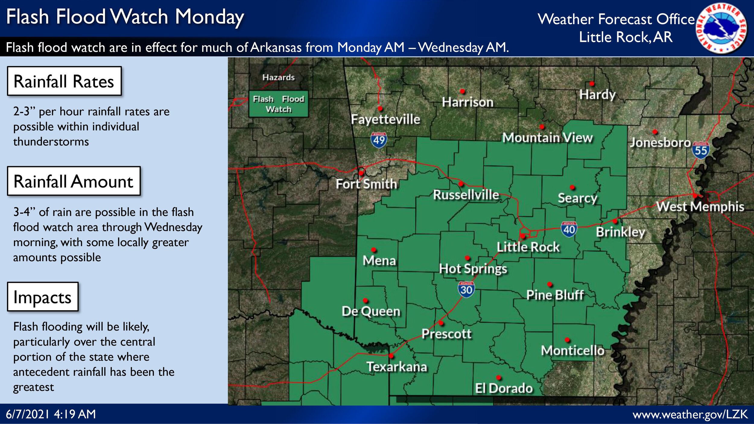
FLASH FLOOD WATCH REMAINS IN EFFECT THROUGH THIS EVENING...

The Flash Flood Watch continues for

* Portions of Arkansas, southeast Oklahoma, and northeast Texas,
  including the following areas, in Arkansas, Columbia,
  Hempstead, Howard, Lafayette, Little River, Miller, Nevada,
  Sevier, and Union. In southeast Oklahoma, McCurtain. In
  northeast Texas, Bowie, Camp, Cass, Franklin, Morris, Red
  River, and Titus.

* Through this evening.

* Additional rainfall totals of 2 to 4 inches, with isolated
  higher amounts in excess of 6 inches, are possible through
  Tuesday afternoon across portions of extreme Northeast Texas,
  McCurtain County Oklahoma, and Southwest Arkansas.

* Flooding may occur in urban and poor drainage areas. Heavy
  rainfall may also cause flooding of creeks, streams, and
  rivers.

PRECAUTIONARY/PREPAREDNESS ACTIONS...

A Flash Flood Watch means that conditions may develop that lead
to Flash Flooding. Flash Flooding is a very dangerous situation.
You should monitor later forecasts and be prepared to take action
should Flash Flood Warnings be issued.

National Weather Service Excessive Rainfall Briefing for SW Arkansas

FLASH FLOOD WATCH IN EFFECT FROM 7 AM CDT THIS MORNING THROUGH
TUESDAY MORNING...

The National Weather Service in Shreveport has issued a

* Flash Flood Watch for portions of Arkansas...northwest Louisiana...
  southeast Oklahoma and northeast Texas, including the following
  areas, in Arkansas, Columbia, Hempstead, Howard, Lafayette, Little
  River, Miller, Nevada, Sevier and Union. In northwest Louisiana,
  Bossier, Caddo, Claiborne and Webster. In southeast Oklahoma,
  McCurtain. In northeast Texas, Bowie, Camp, Cass, Cherokee,
  Franklin, Gregg, Harrison, Marion, Morris, Panola, Red River,
  Rusk, Smith, Titus, Upshur and Wood.

* From 7 AM CDT this morning through Tuesday morning

* Rainfall totals of 2 to 3 inches, with isolated higher amounts
  possible. Rain amounts may occur in a short period of time and may
  impact locations that have seen heavy rainfall over the last few
  days.

* Flooding may occur in urban and poor drainage areas.  Heavy
  rainfall may also cause flooding of creeks, streams, and rivers.

PRECAUTIONARY/PREPAREDNESS ACTIONS...

A Flash Flood Watch means that conditions may develop that lead to
Flash Flooding. Flash Flooding is a very dangerous situation. You
should monitor later forecasts and be prepared to take action should
Flash Flood Warnings be issued.

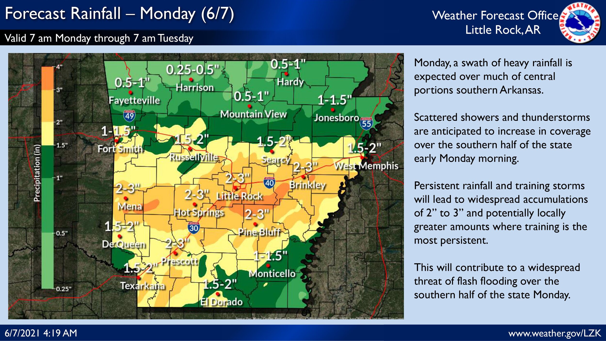
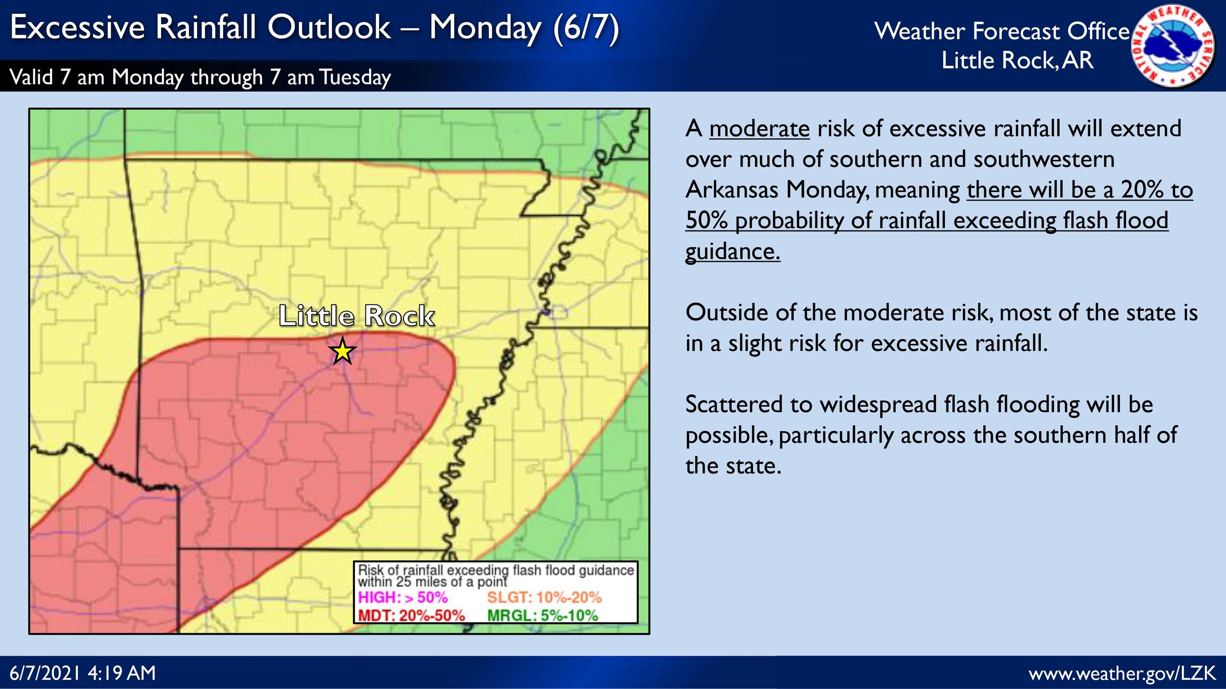
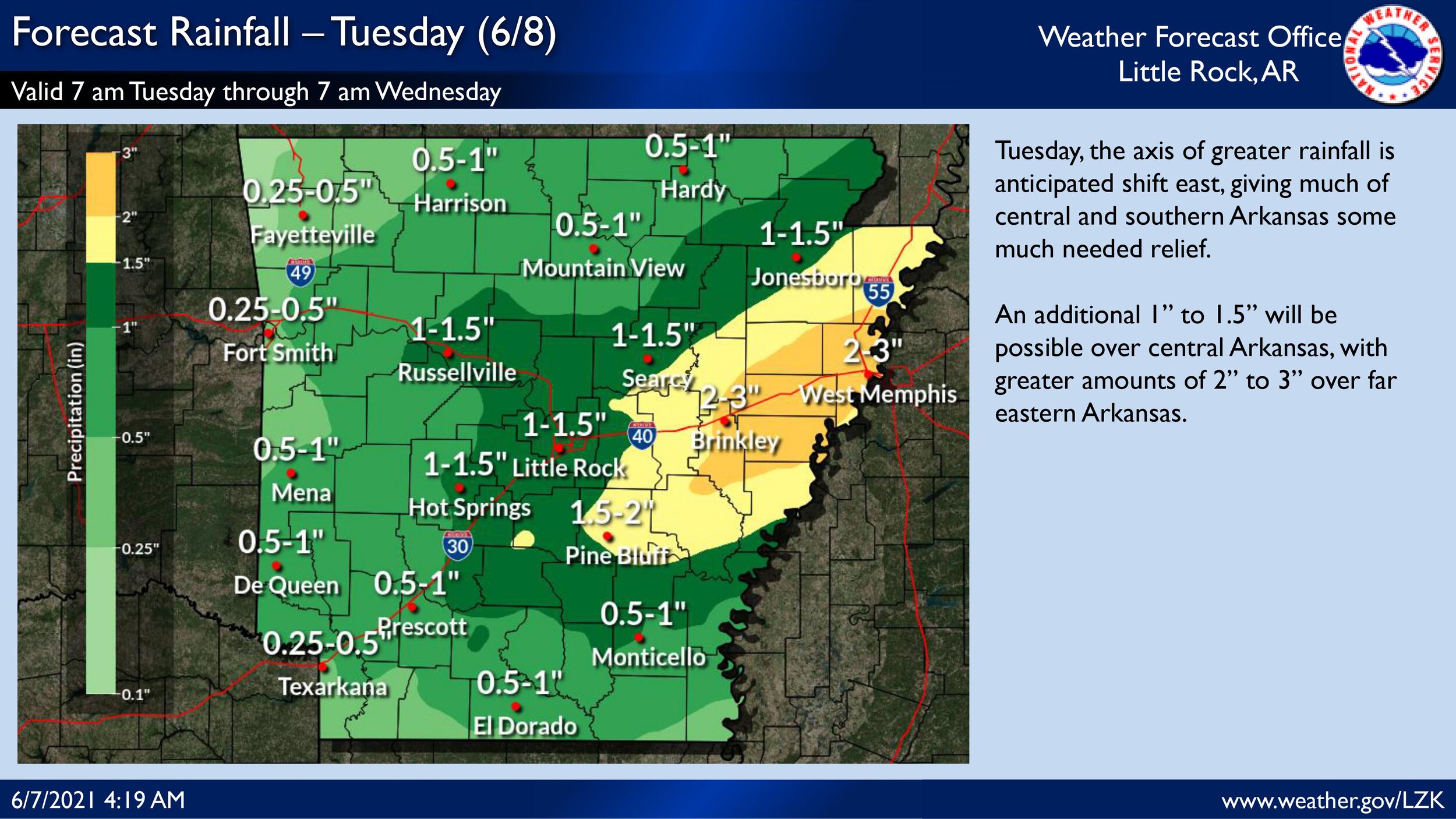
We are expecting an active day across the state regarding heavy rainfall and flash flooding potential. With the morning forecast package, the Weather Prediction Center introduced a Moderate risk of excessive rainfall for much of southwest and central Arkansas. The potential 2 to 3 inches of rain over the risk area with some locally greater amounts coupled with antecedent heavy rainfall the last few days has led to a compromised soil surface and increased flash flooding vulnerability. Please see the attached briefing for more in depth information regarding flash flooding potential over the next few days.

Monday's SW Arkansas COVID-19 Active Case Numbers and Vaccines

Active Cases Data for Sevier County
Total Active Cases: 6
Active Confirmed Cases: 4
Active Probable Cases: 2

Active Cases Data for Howard County
Total Active Cases: 3
Active Confirmed Cases: 2
Active Probable Cases: 1

Active Cases Data for Little River County
Total Active Cases: 2
Active Confirmed Cases: 2
Active Probable Cases: 0

Active Cases Data for Polk County
Total Active Cases: 8
Active Confirmed Cases: 7
Active Probable Cases: 1

Active Cases Data for Pike County
Total Active Cases: 1
Active Confirmed Cases: 1
Active Probable Cases: 0

Friday COVID-19 Active Cases and Vaccines Update from the Arkansas Department of Health

Active Cases Data for Sevier County
Total Active Cases: 9
Active Confirmed Cases: 7
Active Probable Cases: 2

Active Cases Data for Howard County
Total Active Cases: 1
Active Confirmed Cases: 0
Active Probable Cases: 1

Active Cases Data for Little River County
Total Active Cases: 4
Active Confirmed Cases: 3
Active Probable Cases: 1

Active Cases Data for Polk County
Total Active Cases: 12
Active Confirmed Cases: 11
Active Probable Cases: 1

Active Cases Data for Pike County
Total Active Cases: 1
Active Confirmed Cases: 1
Active Probable Cases: 0

Thursday COVID-19 Active Cases Update from the Arkansas Department of Health

Active Cases Data for Sevier County
Total Active Cases: 9
Active Confirmed Cases: 6
Active Probable Cases: 3

Active Cases Data for Howard County
Total Active Cases: 3
Active Confirmed Cases: 2
Active Probable Cases: 1

Active Cases Data for Little River County
Total Active Cases: 6
Active Confirmed Cases: 4
Active Probable Cases: 2

Active Cases Data for Polk County
Total Active Cases: 10
Active Confirmed Cases: 9
Active Probable Cases: 1

Active Cases Data for Pike County
Total Active Cases: 1
Active Confirmed Cases: 1
Active Probable Cases: 0

Tuesday's COVID-19 Active Cases and Vaccines Update from the AR Dept of Health

Active Cases Data for Sevier County
Total Active Cases: 5
Active Confirmed Cases: 4
Active Probable Cases: 1

Active Cases Data for Howard County
Total Active Cases: 4
Active Confirmed Cases: 3
Active Probable Cases: 1

Active Cases Data for Little River County
Total Active Cases: 5
Active Confirmed Cases: 3
Active Probable Cases: 2

Active Cases Data for Polk County
Total Active Cases: 12
Active Confirmed Cases: 10
Active Probable Cases: 2

Active Cases Data for Pike County
Total Active Cases: 1
Active Confirmed Cases: 1
Active Probable Cases: 0

UA Cossatot Phlebotomy Graduates

Six students recently graduated from the UA Cossatot Phlebotomy Technician Program.

This 90 hour Phlebotomy Technician Program prepares professionals to collect blood specimens from clients for the purpose of laboratory analysis. Students will become familiar with all aspects related to blood collection and develop comprehensive skills to perform venipunctures completely and safely. Classroom and lab work includes terminology, anatomy and physiology, blood collection procedures;, specimen hands-on practice; and training in skills and techniques to perform puncture methods.

Pictured left to right/top row:  Instructor Brittany Stone, Franchezca Butler, Kayla Harris, Kyron Starr, Angela Baker. Bottom row:  Blanca Hernandez, Shanika Wright

Pictured left to right/top row: Instructor Brittany Stone, Franchezca Butler, Kayla Harris, Kyron Starr, Angela Baker.
Bottom row: Blanca Hernandez, Shanika Wright

Little River County Chamber of Commerce Awards Banquet

A good time was had at the 2021 Little River Chamber of Commerce Awards Banquet Thursday night at the Barbara Horn Civic Center on the UA Cossatot campus in Ashdown. Award winners were:

Renovation Award: Ashdown Elementary School

New Construction: Davis Feed Co.

Large Business Award: Horatio State Bank - Foreman Branch

Small Business: Next Step Gym / Cutting Edge

Non-Profit Organization: Ashdown Cemetery

Outstanding Health Care Professional: Wes Aylett

Exceptional Law Enforcement Officer: Zane Butler

Foreman Teacher of the Year: Michelle Green

Ashdown Teacher of the Year: Shawnda Chester

UA Cossatot Instructor of the Year: Tamla Heminger

Panther Ambassador of the Year: Emma Wrinkle

Gator Ambassador of the Year: Chris Haywood

Clayton Castleman Public Service Award: Kim Befeld

Steve Pearce Citizen of the Year Award: Matt Richardson

Friday COVID-19 Active Cases and Vaccines Update from the Arkansas Department of Health

Active Cases Data for Sevier County
Total Active Cases: 7
Active Confirmed Cases: 5
Active Probable Cases: 2

Active Cases Data for Howard County
Total Active Cases: 6
Active Confirmed Cases: 6
Active Probable Cases: 0

Active Cases Data for Little River County
Total Active Cases: 4
Active Confirmed Cases: 3
Active Probable Cases: 1

Active Cases Data for Polk County
Total Active Cases: 14
Active Confirmed Cases: 12
Active Probable Cases: 2

Active Cases Data for Pike County
Total Active Cases: 2
Active Confirmed Cases: 2
Active Probable Cases: 0

Severe Weather Possible Across Arkansas Overnight Thursday into Friday Morning

Severe Weather Briefing for Arkansas
This Hazardous Weather Outlook is for portions of south central Arkansas, southwest Arkansas, north central Louisiana, northwest Louisiana, southeast Oklahoma, east Texas and northeast Texas. .Today and Tonight... By tonight, locally heavy rainfall from widespread showers and thunderstorms can produce isolated flash flooding, especially along the U.S. Highway 82 corridor in northeast Texas and southwest Arkansas. .Friday through Wednesday... Showers and thunderstorms will return across the region Thursday night and into Friday morning. This activity will be associated with a squall line, and some of these storms can be strong to severe, particularly north of I-20. Damaging winds will be the primary threat with this activity. SPOTTER INFORMATION STATEMENT... Activation of emergency management personnel...amateur radio operators...and storm spotters may be needed for Thursday night. Please relay any information about observed severe weather to the NWS while following all local, state, and CDC guidelines.

This Hazardous Weather Outlook is for portions of south central Arkansas, southwest Arkansas, north central Louisiana, northwest Louisiana, southeast Oklahoma, east Texas and northeast Texas. .

Today and Tonight... By tonight, locally heavy rainfall from widespread showers and thunderstorms can produce isolated flash flooding, especially along the U.S. Highway 82 corridor in northeast Texas and southwest Arkansas. .

Friday through Wednesday... Showers and thunderstorms will return across the region Thursday night and into Friday morning. This activity will be associated with a squall line, and some of these storms can be strong to severe, particularly north of I-20. Damaging winds will be the primary threat with this activity.

SPOTTER INFORMATION STATEMENT... Activation of emergency management personnel...amateur radio operators...and storm spotters may be needed for Thursday night. Please relay any information about observed severe weather to the NWS while following all local, state, and CDC guidelines.

Thursday COVID-19 Active Cases Update from the Arkansas Department of Health

Active Cases Data for Sevier County
Total Active Cases: 7
Active Confirmed Cases: 4
Active Probable Cases: 3

Active Cases Data for Howard County
Total Active Cases: 7
Active Confirmed Cases: 7
Active Probable Cases: 0

Active Cases Data for Little River County
Total Active Cases: 5
Active Confirmed Cases: 3
Active Probable Cases: 2

Active Cases Data for Polk County
Total Active Cases: 12
Active Confirmed Cases: 9
Active Probable Cases: 3

Active Cases Data for Pike County
Total Active Cases: 2
Active Confirmed Cases: 2
Active Probable Cases: 0

A Success Story From One of Our Former Students at UA Cossatot, Rose Tran

Hello Everyone!

I wanted to share this success story of one of former students, Rose Tran. She was possibly our first international student having been an exchange student in high school, and she gave me permission to share her story. She recently graduated medical school and is starting her residency in the next month.

Tabetha Nguyen

rose tran.png

“WOW! It’s finally the day!

12 years ago my parents sent me on a journey from Vietnam to America, not knowing what was going to come out of it. With lots of questions and lots of unknowns, I went. My graduation is a celebration only possible because of those who have been there for me. It is much more of a celebration of my parents who were so amazingly brave to send their 17-year-old daughter half way across the world. Because of them, I was given opportunities to explore and reach my potentials. It is a celebration of every single person who has touched my life and has taught me countless lessons of kindness, patience, and resilience. ❤️ Thank YOU!”

Tyson Foods Establishes Industrial Maintenance Scholarship with UA Cossatot Foundation

May 24, 2021

UA Cossatot Foundation recently received a $2,500 donation from Tyson Foods to establish the Tyson Technical Maintenance Scholarship.

The scholarship awards one student $2,500 who is in the Industrial Maintenance Program at UA Cossatot. This scholarship application will open in the summer and the recipient will be selected by the UA Cossatot Scholarship Committee in the fall 2021 semester.

UA Cossatot’s Director of Development, Dustin Roberts, said, “We greatly appreciate Tyson Foods'  helping our students succeed. Tyson generously donated valuable equipment to our Industrial Maintenance program on the Lockesburg Campus, was our headline sponsor at Fiesta Fest, which provides scholarships to our students, and most recently establishing the Tyson Technical Maintenance Scholarship!”

For more information on establishing a scholarship with the UA Cossatot Foundation, contact Dustin Roberts at 870-584-1172 or droberts@cccua.edu.

Tuesday's COVID-19 Active Cases and Vaccines Update from the AR Dept of Health

Active Cases Data for Sevier County
Total Active Cases: 5
Active Confirmed Cases: 4
Active Probable Cases: 1

Active Cases Data for Howard County
Total Active Cases: 6
Active Confirmed Cases: 6
Active Probable Cases: 0

Active Cases Data for Little River County
Total Active Cases: 7
Active Confirmed Cases: 7
Active Probable Cases: 0

Active Cases Data for Polk County
Total Active Cases: 8
Active Confirmed Cases: 6
Active Probable Cases: 2

Active Cases Data for Pike County
Total Active Cases: 3
Active Confirmed Cases: 3
Active Probable Cases: 0

COVID19-52421.jpg

Sunday COVID-19 Active Cases and Vaccines Update from the Arkansas Department of Health

Active Cases Data for Sevier County
Total Active Cases: 4
Active Confirmed Cases: 3
Active Probable Cases: 1

Active Cases Data for Howard County
Total Active Cases: 6
Active Confirmed Cases: 6
Active Probable Cases: 0

Active Cases Data for Little River County
Total Active Cases: 7
Active Confirmed Cases: 7
Active Probable Cases: 0

Active Cases Data for Polk County
Total Active Cases: 6
Active Confirmed Cases: 4
Active Probable Cases: 2

Active Cases Data for Pike County
Total Active Cases: 3
Active Confirmed Cases: 3
Active Probable Cases: 0