Weekly Update from State Representative DeAnn Vaught

From the workers clearing our roads to the utility employees doing their best to keep houses warm, we want to extend our deepest appreciation to our essential workers this week.

deann+pic+2.jpg

The General Assembly took an extended recess due to the winter weather across our state. However, House members plan to be back at the Capitol on February 22.

In the upcoming days, the House is expected to vote on two tax relief bills which were advanced by the House Revenue and Taxation Committee on February 9.

SB236 would exempt unemployment benefits paid in 2020 and 2021 from state income tax.

In previous years, an average of 45,000 Arkansans received unemployment. Last year, due to the pandemic, more than 280,000 Arkansans received unemployment benefits. That is approximately 18% of Arkansas taxpayers and $2.6 billion in payments. Taxes are not withheld from unemployment benefits.

SB236 would ensure those Arkansans would not have to pay state taxes on those benefits they received this year and in 2020. The Department of Finance and Administration estimates the bill will have a $51 million impact on revenue for the current fiscal year.

SB236 passed the Senate with unanimous support.

Another tax relief bill before the House next week is HB1361.

HB1361 would exempt COVID-19 relief loans for small businesses, such as the Paycheck Protection Program (PPP), from state income tax.

More than 42,000 PPP loans totaling $3.3 billion were distributed to small businesses in Arkansas last year. These loans are currently exempt from federal income tax.

The unemployment rate in Arkansas is now 4.2%. Recent reports show our state general revenue is $298.7 million or 8.4% more than this time last year.

Net available revenue is 12.3% above forecast. The results include collection increases tied to the income tax due date shift to July from April in the prior fiscal year. These reports help to guide our decision making when considering tax cut proposals.

As a reminder, you can find agendas and links to live streams for all House committee and floor proceedings at www.arkansashouse.org.

Boozman, Advocates Weigh In As Biden Plans to Reinstate Water Protection Rule

By JACQUELINE FROELICH

In the first months of his presidency, Donald Trump issued an executive order rescinding the “Waters of the United States” rule, promulagated by President Barak Obama in 2015 to protect certain streams, wetlands, and groundwater under the Clean Water Act. Now, President Joe Biden has ordered the rule to be reinstated. U.S. Senator John Boozman, (R-AR) claims it will devastate agriculture and industry. Arkansas water quality advocate, Gordon Watkins, says all U.S. waters require protection.

https://www.kuaf.com/post/boozman-advocates-weigh-biden-plans-reinstate-water-protection-rule

boozman.jpg

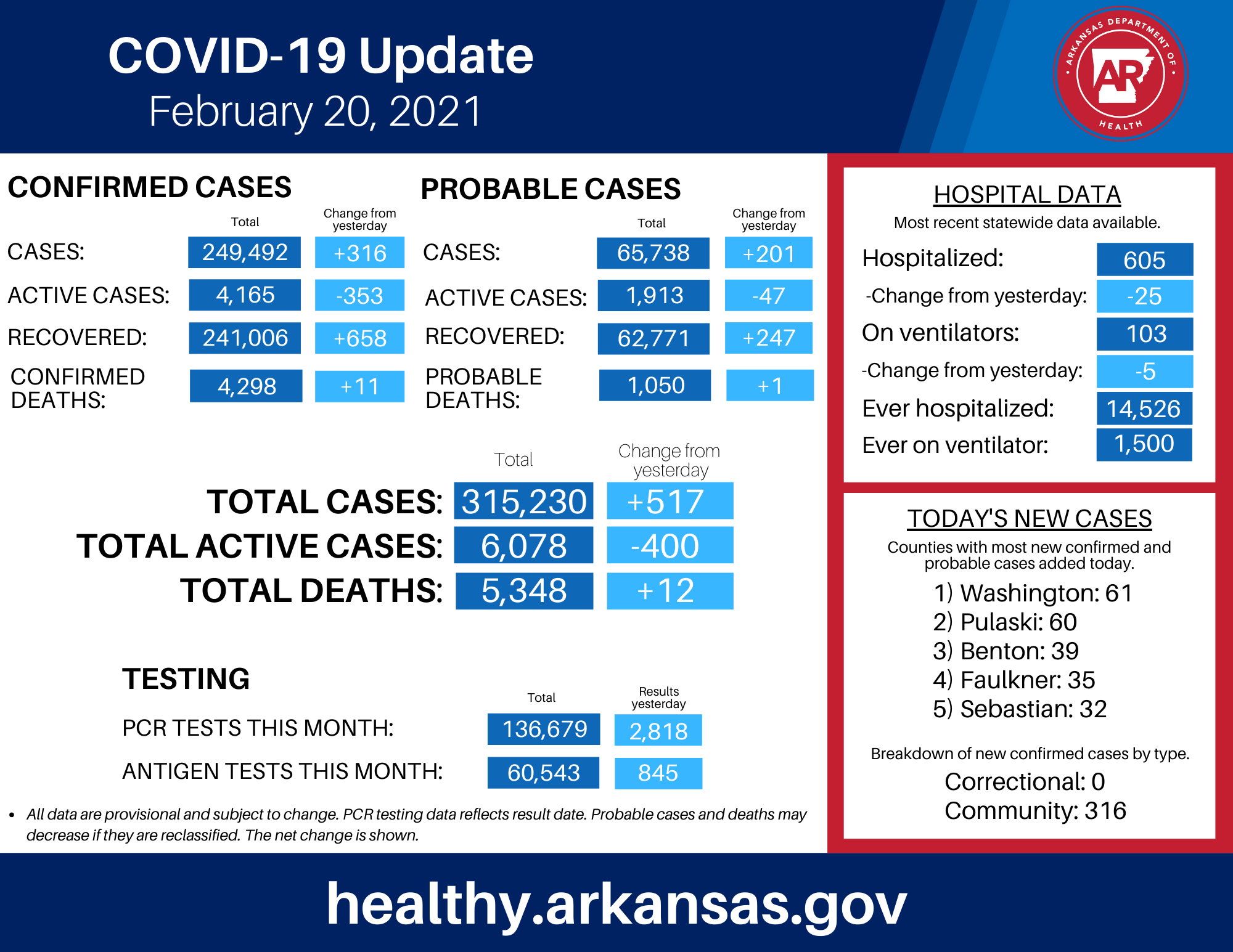
Sunday COVID-19 Update from the Arkansas Department of Health

COVID-19 Metrics for Sevier County
Total Active Cases: 59
Active Confirmed Cases: 27
Active Probable Cases: 32

COVID-19 Metrics for Howard County
Total Active Cases: 34
Active Confirmed Cases: 14
Active Probable Cases: 20

COVID-19 Metrics for Little River County
Total Active Cases: 12
Active Confirmed Cases: 8
Active Probable Cases: 4

COVID-19 Metrics for Polk County
Total Active Cases: 53
Active Confirmed Cases: 36
Active Probable Cases: 17

COVID-19 Metrics for Pike County
Total Active Cases: 23
Active Confirmed Cases: 12
Active Probable Cases: 11

COVID_19_numbers_2_20_21.png
210219_COVID-19_vaccine_update.png

AUDIO: Governor Hutchinson’s Weekly Address | The Rare Winter Storm of 2021

asa+pic+2.jpg

LITTLE ROCK – We still have eight days left in February, and already this is the third snowiest month in Little Rock since we started keeping records in the 1800s. And it is one of the most severe snowstorms statewide as well.

The snow and cold temperatures forced utility companies to employ rolling power outages to reduce the strain on our energy system around the state, and as a result, thousands of homes and businesses lost electricity for a limited amount of time. In addition, low pressure in a supply line cut off natural gas service to 2,300 residents of Pea Ridge, which left many of them without heat.

This record-breaking storm illustrates the degree to which states depend upon each other in a natural crisis, whether it’s an event such as the historic flood of 2019 or a bone-chilling winter storm such as this one. Arkansas was one of more than a dozen states that has endured several days of subfreezing temperatures, and all of this put pressure on energy supplies across the region.

In an effort to reduce the load on the grid before the rolling outages, Entergy, SWEPCO, and other power companies encouraged customers to use only the lights necessary, to set thermostats at sixty-five degrees to sixty-eight degrees, and to delay laundry, dishwashing, and baths until the weather relented.

Peter Main, a spokesman for Southwestern Electric Power Company (SWEPCO), noted in a newspaper interview that energy doesn’t come just from “the power plant next door.”

He said, “What we do in Arkansas helps other states, and what folks do in North Dakota helps Arkansas. It's a matter of small adjustments by each individual.”

How bad was this storm? Gurdon had the most snow in Arkansas with twenty-one inches. Fayetteville set a record with a low temperature of twenty degrees below zero. Little Rock’s fifteen-inch snowfall tied a record from 1918, but the capital city’s low temperature of one-degree below zero wasn’t the coldest ever. Fort Smith’s low of eight-degrees below is its seventh coldest recorded temperature.

The weather has kept many of our road crews away from home for the entire week, and we are grateful for their service. The crew in Maumelle has been working in two shifts and sleeping in the city’s bunk house. Power company linemen have been tromping through snowy woods and climbing ice-covered poles to repair lines. Our police officers have been rescuing drivers and working dozens of accidents at great risk.

As disruptive as this storm has been, it also produced beautiful sights and sounds that we don’t often enjoy in Arkansas. There is something special about the beauty of snow-covered hills and trees. The paved streets have been empty; the traffic is on hills all over the state, and we see our kids – the young ones and the adult ones as well – slide down hills on red Flexible Flyers and brown cardboard boxes.

This rare winter storm soon will be history, and I know it has caused a hardship for many, but I hope that it has produced some warm memories as well.

Secondary Roads Across SW Arkansas Still Have Patchy Ice; Drive With Caution

Photos were taken Thursday Evening,02/18, and Friday Morning, 02/19, by Jon Bunyard
Photo 1: 9th Street, De Queen, Friday Morning
Other 2 Photos at Bellah Mine Thursday Evening

Lt. Gov. Griffin Discusses Decision To Run for AG Instead of Governor

By PAUL GATLING

Roby Brock speaks with Lt. Gov. Tim Griffin about his decision to run for Arkansas attorney general instead of the governorship. Griffin made the announcement earlier this month after Sarah Huckabee Sanders said she'd be joining the race for the GOP gubernatorial nomination, which also includes current Attorney General Leslie Rutledge.

https://www.kuaf.com/post/lt-gov-griffin-discusses-decision-run-ag-instead-governor

COURTESY / LIEUTENANT GOVERNOR'S OFFICE

COURTESY / LIEUTENANT GOVERNOR'S OFFICE

Friday COVID-19 Update from the Arkansas Department of Health

COVID-19 Metrics for Sevier County
Total Cumulative Cases: 2,549
Confirmed Cases: 1,737
Probable Cases: 812
Total Active Cases: 63
Active Confirmed Cases: 31
Active Probable Cases: 32

COVID-19 Metrics for Howard County
Total Cumulative Cases: 1,500
Confirmed Cases: 982
Probable Cases: 518
Total Active Cases: 43
Active Confirmed Cases: 16
Active Probable Cases: 27

COVID-19 Metrics for Little River County
Total Cumulative Cases: 1,112
Confirmed Cases: 844
Probable Cases: 268
Total Active Cases: 18
Active Confirmed Cases: 9
Active Probable Cases: 9

COVID-19 Metrics for Polk County
Total Cumulative Cases: 1,846
Confirmed Cases: 1,582
Probable Cases: 264
Total Active Cases: 59
Active Confirmed Cases: 36
Active Probable Cases: 23

COVID-19 Metrics for Pike County
Total Cumulative Cases: 943
Confirmed Cases: 724
Probable Cases: 219
Total Active Cases: 25
Active Confirmed Cases: 12
Active Probable Cases: 13

Governor Hutchinson Provides Today’s COVID-19 Update

LITTLE ROCK – Governor Asa Hutchinson provided today's update on Arkansas's COVID-19 response.

In its Thursday update, the Arkansas Department of Health reported 253 new cases; 7,323 active cases; 625 hospitalized, which is up 23 from Wednesday; 107 on ventilators, which is down 1 from Wednesday; deaths added today, 10, for a total of 5,323; a total of 314,445 cases; 239,586 recoveries; PCR tests, 2,155; antigen tests, 820.

The Health Department reported that the top counties for new cases are Washington, 42; Benton, 37; Sebastian, 20; Pulaski, 16; and Garland and Independence with 10 each.

Governor Hutchinson released the following statement on today’s COVID-19 numbers:

"Our vaccine numbers have slowed over the past few days, and we anticipate these numbers to increase once the roads clear up throughout the state. We hope that vaccine uptake will continue among those who are eligible. I ask that, once it's your turn, you roll up your sleeve and help protect your community."

Here are today's COVID-19 statewide numbers:

210218_COVID-19_update.png

Here are today's COVID-19 vaccine statewide numbers:

210218_COVID-19_vaccine_update.png

With An Additional 2 1/4 inches, Total Snow/Sleet Accumulation Was 9 3/4 Inches in De Queen

snow pic 7.jpg

The Winter Storm Warning for Southwest Arkansas has expired and the National Weather Service says we can expect a slow warming trend for the next several days with high temperatures back up into the lower 60’s for the middle part of next week.

COVID-19 Update for Thursday from the Arkansas Department of Health

Governor Asa Hutchinson provided today's update on Arkansas's COVID-19 response.

In its Wednesday update, the Arkansas Department of Health reported 667 new cases; 8,239 active cases; 602 hospitalized, which is down 36 from Tuesday; 108 on ventilators, which is down 2 from Tuesday; deaths added today, 26, for a total of 5,313; a total of 314,192 cases; 238,810 recoveries; PCR tests, 1,152; antigen tests, 929.

The Health Department reported that the top counties for new cases are Garland, 100; Benton, 90; Washington, 86; Sebastian, 59; and Pulaski, 47.

Governor Hutchinson released the following statement on today’s COVID-19 numbers:

"We once again saw a decrease in testing yesterday, which was impacted by the weather. We received an additional 18,525 vaccine doses yesterday, and we will continue to administer these doses as quickly as possible. Please continue to take necessary precautions against COVID-19 and limit road travel as much as possible."

Here are today's COVID-19 statewide numbers:

Here are today's COVID-19 vaccine statewide numbers:

210217_COVID-19_vaccine_update.png

COVID-19 Metrics for Sevier County
Total Active Cases: 79
Active Confirmed Cases: 34
Active Probable Cases: 45

COVID-19 Metrics for Howard County
Total Active Cases: 50
Active Confirmed Cases: 18
Active Probable Cases: 32

COVID-19 Metrics for Little River County
Total Active Cases: 20
Active Confirmed Cases: 10
Active Probable Cases: 10

COVID-19 Metrics for Polk County
Total Active Cases: 66
Active Confirmed Cases: 41
Active Probable Cases: 25

COVID-19 Metrics for Pike County
Total Active Cases: 27
Active Confirmed Cases: 11
Active Probable Cases: 16

Arkansas Utilities Call For People To Conserve Energy Or Face Planned Outages

By ALEXANDRIA BROWN & MICHAEL HIBBLEN

Arkansas utility companies are asking people to conserve electricity usage as the state braces for another round of winter weather. Companies say heavy snowfall and unusually cold temperatures have prompted many consumers to use a substantial amount of natural gas and electricity to stay warm in their homes.

Melody Daniel, a spokeswoman for the Arkansas Division of Emergency Management, says lowering thermostats to within the 60 to 65 degree temperature range will help conserve power.

"Heating sources are the biggest draw during these extended cold weather events," Daniel said. "So, if you’re able to reduce that by about five degrees or so, and then bundle up, wear a few extra layers and maybe have a blanket with you, that is just one simple step that most Arkansans can take that will drastically reduce the load on the power grid and help our electricity stay on."

https://www.ualrpublicradio.org/post/arkansas-utilities-call-people-conserve-energy-or-face-planned-outages

Entergy Arkansas worker Jason Penny addresses a problem on a power line Sunday in west Little Rock.CREDIT ENTERGY ARKANSAS

Entergy Arkansas worker Jason Penny addresses a problem on a power line Sunday in west Little Rock.

CREDIT ENTERGY ARKANSAS

Additional Snow From Second Winter Storm Continues to Top Roadways

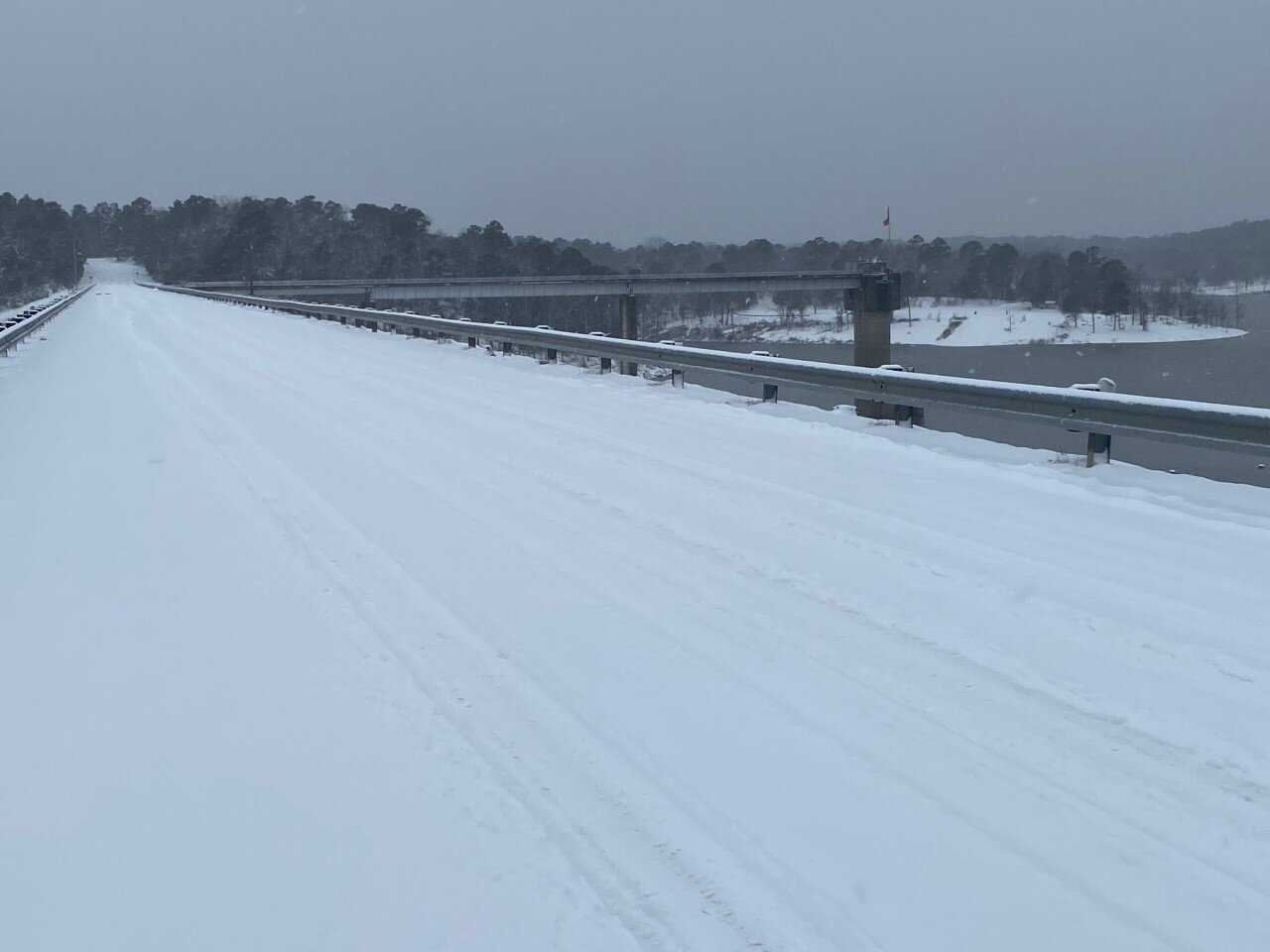
Snow-covered Road near De Queen Lake Wednesday morning, 02/17/21 - Photo by Jon Bunyard

Snow-covered Road near De Queen Lake Wednesday morning, 02/17/21 - Photo by Jon Bunyard

De Queen Lake Road at De Queen Dam Wednesday Morning, 02/17/21 - Photo by Jon Bunyard

De Queen Lake Road at De Queen Dam Wednesday Morning, 02/17/21 - Photo by Jon Bunyard

Updated COVID Numbers for SW Arkansas on Wednesday

COVID-19 Metrics for Sevier County
Total Active Cases: 89
Active Confirmed Cases: 37
Active Probable Cases: 52

COVID-19 Metrics for Howard County
Total Active Cases: 54
Active Confirmed Cases: 20
Active Probable Cases: 34

COVID-19 Metrics for Little River County
Total Active Cases: 25
Active Confirmed Cases: 11
Active Probable Cases: 14

COVID-19 Metrics for Polk County
Total Active Cases: 74
Active Confirmed Cases: 47
Active Probable Cases: 27

COVID-19 Metrics for Pike County
Total Active Cases: 25
Active Confirmed Cases: 13
Active Probable Cases: 12

 
map corona.png
COVID_19_numbers_2_16_21_(1).png

Winter Storm Warning Continues Through Thursday Morning; Slow Warming Trend to Follow

nws 1.png
...Conditions to Deteriorate as Winter Storm Approaches...

.A significant winter storm producing a mix of snow, sleet, and
freezing rain to threaten the region today and not totally ending
until during the day Thursday. Wintry precipitation is expected
to be primarily snow along and north of Interstate 30, a mix of
snow, sleet and freezing rain around the Interstate 20 corridor,
and primarily freezing rain over Deep East Texas and Central
Louisiana. Power outages will be a risk in all areas, but
especially where freezing rain will be predominant. Of course
travel remains difficult in most of the region and any recent
improvement will be lost once this new event sets in. Temperatures
will not be nearly as cold as the last 24 hours, but will remain
well below normal.

...WINTER STORM WARNING REMAINS IN EFFECT UNTIL NOON CST
THURSDAY...

* WHAT...Heavy mixed precipitation expected. Total snow
  accumulations of up to 6 inches across southwest Arkansas and
  ice accumulations of around one half of an inch south of I-20.

* WHERE...Portions of north central and northwest Louisiana,
  southeast Oklahoma, south central and southwest Arkansas and
  east and northeast Texas.

* WHEN...Until noon CST Thursday.

* IMPACTS...Power outages and tree damage are likely due to the
  ice. Travel could be nearly impossible. The hazardous
  conditions could impact the morning or evening commute.

PRECAUTIONARY/PREPAREDNESS ACTIONS...

If you must travel, keep an extra flashlight, food, and water in
your vehicle in case of an emergency.

The latest road conditions for the state you are calling from can
be obtained by calling 5 1 1.

Today

Snow. High near 28. Wind chill values as low as 10. East wind around 5 mph. Chance of precipitation is 80%. Total daytime snow accumulation of 2 to 4 inches possible.

Tonight

A slight chance of snow, mixing with sleet after 9pm, then gradually ending. Cloudy, with a low around 22. Northeast wind around 5 mph. Chance of precipitation is 20%.

Thursday

Mostly cloudy, with a high near 32. North wind 5 to 10 mph.

Thursday Night

Partly cloudy, with a low around 10. North wind around 5 mph.

Friday

Sunny, with a high near 37. Calm wind becoming southwest around 5 mph in the afternoon.

Friday Night

Partly cloudy, with a low around 17.

Saturday

Mostly sunny, with a high near 44.

Saturday Night

Mostly cloudy, with a low around 33.

Sunday

A 20 percent chance of showers after noon. Mostly cloudy, with a high near 50.

Sunday Night

A 20 percent chance of showers before midnight. Partly cloudy, with a low around 29.

Monday

Sunny, with a high near 56.

Monday Night

Mostly clear, with a low around 31.

Tuesday

Sunny, with a high near 61.

Nurses Come Out of Retirement To Assist With COVID-19 Vaccinations

By ANTOINETTE GRAJEDA

As the rollout of the COVID-19 vaccine continues across Arkansas, some nurses are coming out of retirement to help with the distribution. Nurses says it's been challenging because they don't have enough vaccines for all of the volunteers.

https://www.kuaf.com/post/nurses-come-out-retirement-assist-covid-19-vaccinations

STOCK IMAGE

STOCK IMAGE

UA Cossatot - All Campuses Will Be Closed Through the Rest of the Week; Another Winter Storm on the Way

“Due to the continuing dangerous road conditions in the area and the possibility of another extended winter storm all UA Cossatot campuses will be closed for the rest of this week (Wednesday, February 16th, Thursday, February 17th, and Friday, February 18th). UA Cossatot fully expects to be open under normal hours on Monday, February 22nd.”

Dr. Steve Cole
Chancellor
UA Cossatot

snow pic tuesday.jpg

Winter Storm Warning On The Way For Tonight Through Thursday Noon

...Next winter storm will push into our area tonight and
continue through Thursday morning...

...WINTER STORM WARNING REMAINS IN EFFECT FROM 6 PM THIS EVENING
TO NOON CST THURSDAY...
...WIND CHILL ADVISORY IS CANCELLED...

* WHAT...A wintry mix of snow, sleet, and freezing rain. Snow and
  sleet accumulations will range from less than 2 inches south of
  the I-20 corridor to 5 to 8 inches north of the I-30 corridor.
  Ice accumulations of a quarter of an inch to a half of an inch
  with localized higher amounts will be possible from Deep East
  Texas across northwestern Louisiana, central Louisiana, and into
  south- central Arkansas.

* WHERE...Portions of north central and northwest Louisiana,
  southeast Oklahoma, south central and southwest Arkansas and
  east and northeast Texas.

* WHEN...From 6 PM this evening to noon CST Thursday.

* IMPACTS...Treacherous road conditions will continue across the
  region. Locations with over a quarter inch of ice will see
  downed limbs and powerlines which will lead to the possibility
  of widespread power outages. Cold temperatures will continue to
  make extended time outdoors dangerous with the risk of
  hypothermia.

PRECAUTIONARY/PREPAREDNESS ACTIONS...

If you must travel, keep an extra flashlight, food, and water in
your vehicle in case of an emergency.

The latest road conditions for the state you are calling from can
be obtained by calling 5 1 1.

Tonight

Snow, mainly after 9pm. Low around 18. Wind chill values as low as 10. Southeast wind around 5 mph. Chance of precipitation is 80%. New snow accumulation of 1 to 3 inches possible.

Wednesday

Snow before noon, then snow, freezing rain, and sleet. High near 28. Wind chill values as low as 9. Northeast wind around 5 mph. Chance of precipitation is 90%. Little or no ice accumulation expected. New snow and sleet accumulation of 3 to 5 inches possible.

Wednesday Night

A slight chance of snow showers and freezing rain before midnight. Cloudy, with a low around 21. Northeast wind around 5 mph. Chance of precipitation is 20%.

Thursday

Mostly cloudy, with a high near 37. North wind 5 to 10 mph.

Thursday Night

Partly cloudy, with a low around 11.

Friday

Sunny, with a high near 38.

Friday Night

Partly cloudy, with a low around 17.

Saturday

Mostly sunny, with a high near 44.

Saturday Night

Mostly cloudy, with a low around 33.

Sunday

A 30 percent chance of showers. Mostly cloudy, with a high near 52.

Sunday Night

A 30 percent chance of showers. Mostly cloudy, with a low around 32.

Monday

Mostly sunny, with a high near 57.

Snow, Bitter Cold Impact Livestock In Arkansas

By GEORGE JARED/ TALK BUSINESS & POLITICS

Single-digit wind chills, freezing water in pipes and troughs, and high snow loads on roofs are causing concerns for poultry and cattle operations, specialists from the University of Arkansas System Division of Agriculture said Monday.

The record-setting storm front that stretches from Texas to Maine has caused millions to lose power as snowfall totals and bitter cold ravage almost half the country, according to the National Weather Service.

Low temperatures reported Monday morning to the National Weather Service included minus five at Compton, zero at Lead Hill and two degrees at Gilbert. At noon Monday, the North Little Rock airport had 10.9 inches of snow, while Greers Ferry, Perryville and Vilonia all reported 11 inches of snow, according to the National Weather Service.

https://www.ualrpublicradio.org/post/snow-bitter-cold-impact-livestock-arkansas

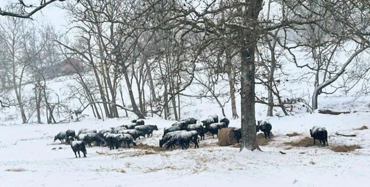
Cattle in the snow at a farm in Carroll County, Arkansas.CREDIT ARKANSAS FARM BUREAU

Cattle in the snow at a farm in Carroll County, Arkansas.

CREDIT ARKANSAS FARM BUREAU