
Governor Asa Hutchinson provides an update to media on Monday, August 31, 2020, live at 1:30 p.m. regarding Arkansas's COVID-19 response.
Sunday's COVID-19 Update
COVID-19 Metrics for Sevier County
Cases
Total Positive: 1,153
Active Positive: 41
Recovered: 1,100
Deaths: 12
Negatives: 5,500
COVID-19 Metrics for Howard County
Cases
Total Positive: 421
Active Positive: 37
Recovered: 379
Deaths: 5
Negatives: 3,123
COVID-19 Metrics for Little River County
Cases
Total Positive: 276
Active Positive: 15
Recovered: 247
Deaths: 14
Negatives: 1,429
COVID-19 Metrics for Polk County
Cases
Total Positive: 223
Active Positive: 30
Recovered: 190
Deaths: 3
Negatives: 3,041
COVID-19 Metrics for Pike County
Cases
Total Positive: 172
Active Positive: 14
Recovered: 157
Deaths: 1
Negatives: 1,703


AUDIO: Governor Hutchinson’s Weekly Address | Preserving the Main Streets of Arkansas
LITTLE ROCK – The COVID-19 pandemic has threatened the survival of many small businesses in Arkansas, and today I’d like to share good news about a grant program that will help. It is the Arkansas Historic Preservation and Main Street Arkansas grants.
First, though, I’d like to discuss the good news about our unemployment rate. For months before the pandemic, our unemployment rate had remained at historic lows and always below the national average. As COVID-19 slowed the economy, our rate jumped to 10.8 percent unemployment. But we have seen impressive improvement. In July, our rate was back to 7.1 percent, which is about three percentage points below the national average.
This is encouraging for the many cities that participate in the Main Street Arkansas and the Arkansas Historic Preservation Program. The mission of these two programs is to help revitalize the historic commercial centers that are essential to the economic health of many communities. The cities will receive grants to help jumpstart their economies as we move out of the pandemic.
Main Street America surveyed its members this spring to assess the effect of the coronavirus, including the likelihood the members would have to close shop if the disruption continued. Of the 213 Arkansas business owners who responded, 32 percent said they likely would be out of business within three months. Thirty percent reported they might have to close after five months.
Jackie Wolven is executive director of Main Street Eureka Springs. The results of that survey are a good representation of what has happened in that historic town. Five stores didn’t survive. But she is totally optimistic about the future. Jackie and the other leaders will identify artisans and business people to put in the empty store fronts, then release the grants after the first of the year. As she put it, Eureka Springs is ready to rock and roll.
Small business are the anchors of our communities. Many of the mom-and-pop shopkeepers grew up in the town where they now own a store. They are part of the social fabric of our small towns as well as key to the towns’ economic health.
The Department of Parks, Heritage, and Tourism supports these communities through annual Downtown Revitalization Grants. Department Secretary Stacy Hurst recently announced that her agency would more than double its funding to $559,000 for the next year. Funding for the grants comes through the Real Estate Transfer Tax. The grants range from $3,000 to $25,000.
Our small towns and the owners who do business there are a link to our history and a reminder of where we came from. They are the building blocks of our economy. Main Street Arkansas and the Arkansas Historic Preservation Program are standing with them to secure the future.
Friday's COVID-19 Updated Numbers and Maps
COVID-19 Metrics for Sevier County
Cases
Total Positive: 1,146
Active Positive: 46
Recovered: 1,088
Deaths: 12
Negatives: 5,466
COVID-19 Metrics for Howard County
Cases
Total Positive: 407
Active Positive: 33
Recovered: 369
Deaths: 5
Negatives: 3,054
COVID-19 Metrics for Little River County
Cases
Total Positive: 274
Active Positive: 29
Recovered: 231
Deaths: 14
Negatives: 1,414
COVID-19 Metrics for Polk County
Cases
Total Positive: 218
Active Positive: 32
Recovered: 182
Deaths: 4
Negatives: 2,990
COVID-19 Metrics for Pike County
Cases
Total Positive: 167
Active Positive: 17
Recovered: 149
Deaths: 1
Negatives: 1,685


VIDEO: Governor Hutchinson Provides COVID-19 Update Friday (08.28.20) 130PM
Governor Asa Hutchinson provides an update to media on Friday, August 28, 2020, live at 1:30 p.m. regarding Arkansas’s COVID-19 response.
Governor Hutchinson Announces DHS to Move 700 Off Wait List For Developmental Disabilities Aid

LITTLE ROCK – The Arkansas Department of Human Services (DHS) will be adding 700 families to the program that provides in-home and community-based services to Arkansans who are eligible for assistance through Developmental Disabilities Services (DDS), Governor Asa Hutchinson announced at a press conference today.
“This is a significant initiative for these families,” Governor Hutchinson said. “The clients will receive assistance with the day-to-day tasks that most of us perform without thinking about them. This offers them a new level of independence.”
The additional slots will be funded through a new premium tax in the Provider-Led Arkansas Shared Savings Entity (PASSE) program and added to the Community and Employment Supports (CES) Waiver program, known as the DD waiver. PASSE has already brought in about $15 million to fund slots in this program.
Clients in the program can live in their homes and communities rather than in an institution because of the services provided, including supported living, adaptive equipment, specialized medical supplies, and supported employment. These services are aren’t included under traditional Medicaid programs.
This is the second time Governor Hutchinson and DHS have expanded the number of people in the program. In 2016, the Tobacco Settlement Fund Commission agreed to allocate unspent funds to cover 500 new slots.
“We are so excited to be able to provide services to so many more families, many of whom have been waiting for years to be a part of this program,” said DDS Director Melissa Stone. “I appreciate the help of the Governor, the Legislature, and the PASSEs to move this forward.”
Fit 4 Life with Dr Andi Reeves
Sevier County Libraries Closing Early Thursday
Due to possible inclement weather from tropical storm Laura, all Sevier County Libraries will close at 12 noon Thursday, August 27. Thank you for your patience. Everyone please stay safe. Turn around don't drown!!!!
Warnings and Watches Issued Today from the National Weather Service

Hurricane and Tropical Storm Warnings have been issued for portions of the forecast area in response to Hurricane Laura impacting the region.

A Flash Flood Watch is in effect for nearly all of our area through 7 AM Friday #TSLaura is expected to bring widespread rainfall amounts of 3-6 inches w/ isolated higher amounts near 8 inches. Remember, #TurnAroundDontDrown!

Sporadic tornadoes will be possible within the rain bands of Hurricane Laura today. The greatest tornado risk overnight will be over the northeastern quadrant of the hurricane, primarily over areas of North Central Louisiana.
Thursday COVID-19 Numbers from the Arkansas Department of Health
COVID-19 Metrics for Sevier County
Cases
Total Positive: 1,142
Active Positive: 49
Recovered: 1,081
Deaths: 12
Negatives: 5,437
COVID-19 Metrics for Howard County
Cases
Total Positive: 398
Active Positive: 26
Recovered: 367
Deaths: 5
Negatives: 3,039
COVID-19 Metrics for Little River County
Cases
Total Positive: 271
Active Positive: 35
Recovered: 222
Deaths: 14
Negatives: 1,409
COVID-19 Metrics for Polk County
Cases
Total Positive: 212
Active Positive: 31
Recovered: 178
Deaths: 3
Negatives: 2,968
COVID-19 Metrics for Pike County
Cases
Total Positive: 163
Active Positive: 17
Recovered: 145
Deaths: 1
Negatives: 1,676


VIDEO: Governor Hutchinson Makes Announcement on Developmental Disability Waiver Program
Governor Asa Hutchinson will announce Arkansas Department of Human Services (DHS) plans regarding developmental disability waiver program at 10 a.m. Thursday in the Governor’s Conference Room.
De Queen Public Schools Closed Thursday Due to Tropical Storm Warning

ArcBest Leads State-based Firms on Forbes Employers’ List
Fort Smith-based supply chain logistics firm ArcBest has been recognized as one of Forbes’ best employers on its annual list of America’s Best-In-State Employers for 2020.
The award is presented by Forbes and Statista Inc., the world-leading statistics portal and industry ranking provider. ArcBest ranked No. 2 in the state of Arkansas, the highest state-based group among the 30 on the list. Louisiana-based Entergy is ranked No. 1. FedEx, Springdale Public Schools and the U.S. Department of the Interior round out the top five.
https://talkbusiness.net/2020/08/arcbest-leads-state-based-firms-on-forbes-employers-list/
ArcBest leads state-based firms on Forbes employers' list - Talk Business & Politics
Fort Smith-based supply chain logistics firm ArcBest has been recognized as one of Forbes' best employers on its annual list of America's Best-In-State Employers for 2020. The award is presented by Forbes and Statista Inc., the world-leading statistics portal and industry ranking provider. ArcBest ranked No.
UAMS Receives $10.6 million Grant for Proteomics Research
The National Institutes of Health awarded the University of Arkansas for Medical Sciences a $10.6 million grant for biomedical research, the school announced Wednesday (Aug. 26).
UAMS said the money will “greatly expand” proteomics resources and will establish the IDeA National Resource for Quantitative Proteomics as the first NIH National Resource in Arkansas. It will also advance UAMS’s effort to receive a National Cancer Institute designation.
Proteomics is the large-scale study of proteins that can lead to the development of new therapies and screening approaches for many diseases, including cancer.
https://talkbusiness.net/2020/08/uams-receives-10-6-million-grant-for-proteomics-research/
UAMS receives $10.6 million grant for proteomics research - Talk Business & Politics
The National Institutes of Health awarded the University of Arkansas for Medical Sciences a $10.6 million grant for biomedical research, the school announced Wednesday (Aug. 26). UAMS said the money will "greatly expand" proteomics resources and will establish the IDeA National Resource for Quantitative Proteomics as the first NIH National Resource in Arkansas.
Tyson Foods the Largest U.S. Chicken Processor in 2019; Pilgrim's 2nd
Springdale-based Tyson Foods was in 2019 king of the nation’s broiler production with 200.47 million pounds of ready-to-cook chicken produced each week. Tyson Foods slaughtered 38.3 million chicken a week at an average weight of 6 pounds, according to WattAgNet’s annual survey.
The closest to Tyson Foods by weekly production is Pilgrim’s Pride Corp., based in Greely, Colo., and a subsidiary of JBS. Pilgrim’s reports 160.04 million pounds of ready-to-cook chicken going to market each week. Pilgrim’s slaughters an average of 30.3 million chickens each week at an average bird weight of 5.78 pounds.
Tyson Foods the largest U.S. chicken processor in 2019; George's ranked 9th - Talk Business & Politics
Springdale-based Tyson Foods was in 2019 king of the nation's broiler production with 200.47 million pounds of ready-to-cook chicken produced each week. Tyson Foods slaughtered 38.3 million chicken a week at an average weight of 6 pounds, according to WattAgNet's annual survey.
Wood product maker to invest $23 million, add jobs at North Little Rock plant
Koppers, a global provider of treated wood products, announced Tuesday (Aug. 25) that it plans to invest a minimum of $23 million and increase the number of workers at its North Little Rock facility over the next two years.
The investment will be used for new construction and to purchase equipment that will allow Koppers to upgrade and modernize the company’s processes and further improve its environmental footprint.
Koppers employs 80 in North Little Rock. It did not disclose the amount of new jobs it would add.
Wood product maker to invest $23 million, add jobs at North Little Rock plant - Talk Business & Politics
Koppers, a global provider of treated wood products, announced Tuesday (Aug. 25) that it plans to invest a minimum of $23 million and increase the number of workers at its North Little Rock facility over the next two years.
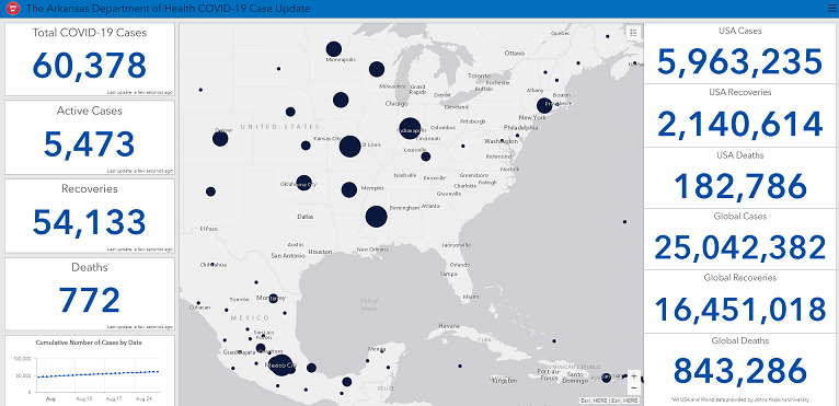
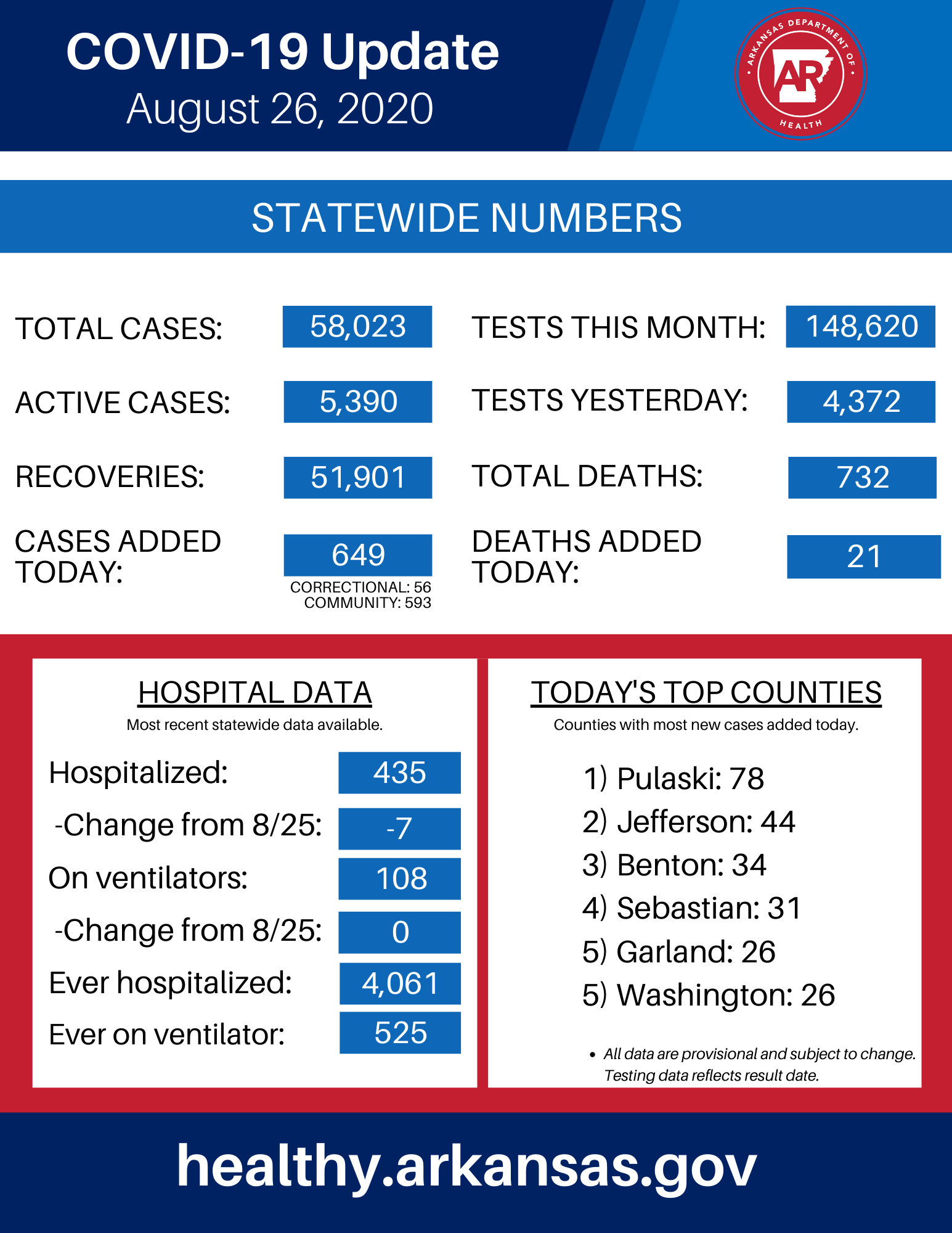
Wednesday COVID-19 Update from the AR Department of Health
COVID-19 Metrics for Sevier County
Cases
Total Positive: 1,134
Active Positive: 50
Recovered: 1,072
Deaths: 12
Negatives: 5,416
COVID-19 Metrics for Howard County
Cases
Total Positive: 398
Active Positive: 28
Recovered: 365
Deaths: 5
Negatives: 3,036
COVID-19 Metrics for Little River County
Cases
Total Positive: 265
Active Positive: 37
Recovered: 215
Deaths: 13
Negatives: 1,404
COVID-19 Metrics for Polk County
Cases
Total Positive: 208
Active Positive: 32
Recovered: 174
Deaths: 2
Negatives: 2,954
COVID-19 Metrics for Pike County
Cases
Total Positive: 161
Active Positive: 23
Recovered: 137
Deaths: 1
Negatives: 1,670


VIDEO: Governor Hutchinson Provides COVID-19 Update Wednesday (08.26.20) 130PM
Governor Asa Hutchinson provides an update to media on Wednesday, August 26, 2020, live at 1:30 p.m. regarding Arkansas's COVID-19 response.
Watches and Warnings From the National Weather Service

This product covers ArkLaTex

**Major Hurricane Laura Continues to Strengthen across the Central
Gulf of Mexico and is Expected to Make Landfall Tonight**

NEW INFORMATION
---------------

* CHANGES TO WATCHES AND WARNINGS:
    - None

* CURRENT WATCHES AND WARNINGS:
    - A Tropical Storm Warning is in effect for Bienville, Bossier,
      Bowie, Caddo, Caldwell, Camp, Cass, Cherokee, Claiborne,
      Columbia, Grant, Gregg, Harrison, Hempstead, Howard, Jackson,
      La Salle, Lafayette, Lincoln, Little River, Marion, Miller,
      Morris, Nevada, Ouachita, Panola, Rusk, Sevier, Smith, Union,
      Union, Upshur, Webster, and Winn
    - A Hurricane Warning is in effect for Angelina, De Soto,
      Nacogdoches, Natchitoches, Red River, Sabine, Sabine, San
      Augustine, and Shelby

* STORM INFORMATION:
    - About 330 miles south-southeast of Natchitoches LA
    - 27.0N 92.0W
    - Storm Intensity 125 mph
    - Movement Northwest or 310 degrees at 16 mph

SITUATION OVERVIEW
------------------

Hurricane Laura continues strengthen and move northwest across the
warm waters of the Gulf of Mexico. Laura recently strengthened
into a major hurricane and is now expected to achieve Category Four
status with peak sustained winds of 145 mph early this evening,
before making landfall later tonight along the coast of extreme
Southwest Louisiana. Laura will remain a hurricane for some time
as it moves inland early tomorrow morning before weakening to a
tropical storm as it moves north across East Texas and Northwest
Louisiana from late morning through early afternoon on Thursday.
With the system moving inland, damaging wind gusts, inland
flooding, and isolated tornadoes are expected across the area.

POTENTIAL IMPACTS
-----------------

* WIND:
Protect against life-threatening wind having possible extensive
impacts across Deep East Texas and West Central Louisiana.
Potential impacts in this area include:

    - Roof damage to sturdy buildings, with some having
      window, door, and garage door failures leading to structural
      damage. Mobile homes severely damaged. Damage could be
      accentuated by airborne projectiles.
    - Many large trees uprooted along with fences and
      roadway signs blown over. Downed trees will become more
      common as the ground gets saturated with heavy rain.
    - Some roads impassable from debris, and more within urban
      or heavily wooded places. Several access routes could become
      impassable.
    - Large areas with power and communications outages.

Also, protect against dangerous wind having possible limited to
significant impacts across the remainder of locations in North
Louisiana, Southwest and South Central Arkansas, and in East
Texas south and east of a Quitman to Clarksville line. Potential
impacts in these areas include:

    - Limited roof and shingle damage possible.
    - Large branches downed and some trees uprooted. Downed trees
      will become more common as the ground gets saturated with
      heavy rain.
    - Some roads may become blocked by downed trees.
    - Scattered areas with power and communications outages.

* FLOODING RAIN:
Protect against life-threatening rainfall flooding having possible
extensive impacts across Southwest and South Central Arkansas,
Northern Louisiana west and north of a Colfax to Monroe line, East
Texas east of an Alto, to Tyler, to Clarksville line, and also
extreme Southeast Oklahoma. Potential impacts include:

    - Major rainfall flooding may prompt many evacuations and
      rescues.
    - Small streams, creeks, bayous, and ditches may rapidly
      overflow their banks in multiples places.
    - Flood waters can enter many structures within multiple
      communities. Many places where flood waters may cover
      escape routes. Streets and parking lots become flooded with
      underpasses submerged. Driving conditions become dangerous.
    - Many road and bridge closures with some weakened or washed
      out.

Protect against dangerous rainfall flooding having possible
significant impacts across the remainder of East Texas and North
Louisiana.

* TORNADOES:
Protect against a tornado event having possible limited impacts
across ArkLaTex. Potential impacts include:

    - The occurrence of isolated tornadoes can hinder the execution
      of emergency plans during tropical events.
    - A few places may experience tornado damage, along with power
      and communications disruptions.
    - Locations could realize roofs peeled off buildings, chimneys
      toppled, mobile homes pushed off foundations or overturned,
      large tree tops and branches snapped off, shallow-rooted trees
      knocked over, moving vehicles blown off roads, and small boats
      pulled from moorings.

PRECAUTIONARY/PREPAREDNESS ACTIONS
----------------------------------

* EVACUATIONS:

No evacuations at this time. Heed instructions from local emergency
management officials.

For those not under evacuation orders, assess the risk from wind,
falling trees, and flooding at your location. If you decide to move,
relocate to a safer location nearby.

* OTHER PREPAREDNESS INFORMATION:

Now is the time to complete all preparations to protect life and
property in accordance with your emergency plan. Ensure you are in
a safe location before the onset of strong winds or possible
flooding.

Failure to adequately shelter may result in serious injury or loss
of life. Always heed the advice of local officials and comply with
any orders that are issued. Remember, during the storm 9 1 1
Emergency Services may not be able to immediately respond if
conditions are unsafe. This should be a big factor in your decision
making.

Keep cell phones well charged. Cell phone chargers for automobiles
can be helpful, but be aware of your risk for deadly carbon monoxide
poisoning if your car is left idling in a garage or other poorly
ventilated area.

Rapidly rising flood waters are deadly. If you are in a flood-prone
area, consider moving to higher ground. Never drive through a
flooded roadway. Remember, turn around don`t drown!

If in a place that is vulnerable to high wind, such as near large
trees or in a manufactured home, consider moving to a safer shelter
before the onset of strong winds or flooding.

Closely monitor weather.gov, NOAA Weather radio or local news
outlets for official storm information. Be ready to adapt to
possible changes to the forecast. Ensure you have multiple ways
to receive weather warnings.

There is a threat from tornadoes with this storm. Have multiple
ways to receive Tornado Warnings. Be ready to shelter quickly.

* ADDITIONAL SOURCES OF INFORMATION:
- For information on appropriate preparations see ready.gov
- For information on creating an emergency plan see getagameplan.org
- For additional disaster preparedness information see redcross.org
Hazardous Weather Outlook
Hazardous Weather Outlook...UPDATED
National Weather Service Shreveport LA
1230 PM CDT Wed Aug 26 2020
Sevier-Howard-Little River-Hempstead-Nevada-Miller-Lafayette-
Columbia-Union-Caddo-Bossier-Webster-Claiborne-Lincoln-Bienville-
Jackson-Ouachita-Winn-Grant-Caldwell-La Salle-Bowie-Camp-Morris-
Cass-Upshur-Marion-Smith-Gregg-Harrison-Cherokee-Rusk-Panola-
1230 PM CDT Wed Aug 26 2020

This Hazardous Weather Outlook is for southern Arkansas, northern
and central Louisiana and for northeast Texas.

.DAY ONE...This Afternoon and Tonight...

Major Hurricane Laura is expected to make landfall near the Texas
and Louisiana border overnight. A Tropical Storm Warning is in
effect through Thursday. Showers and thunderstorms are forecast to
increase in coverage from the south today, and then a break this
evening with conditions further deteriorating after midnight and
especially in the predawn hours as heavy precipitation begins to
spread into the region. Heavy rainfall, strong and gusty winds,
and possible tornadoes are expected overnight. A Flash Flood
Watch is in effect from this evening through Friday morning.

.DAYS TWO THROUGH SEVEN...Thursday through Tuesday...

Hurricane Laura will continue all day on Thursday, bringing the
brunt of heavy rainfall, strong and gusty winds, and the tornado
threat Thursday morning and afternoon with conditions beginning to
improve from the south by Thursday evening. In the wake of Laura,
afternoon thunderstorms will remain possible through the weekend
and into early next week.

.SPOTTER INFORMATION STATEMENT...

Remote activation of emergency management personnel, amateur
radio operators and storm spotters may be needed through
Thursday. Please relay any information about observed severe
weather to the NWS while following all local, state, and CDC
guidelines.
Flash Flood Warning
Flash Flood Warning

BULLETIN - EAS ACTIVATION REQUESTED
Flash Flood Warning
National Weather Service Shreveport LA
1106 AM CDT Wed Aug 26 2020

The National Weather Service in Shreveport has issued a

* Flash Flood Warning for...
  Northwestern Howard County in southwestern Arkansas...
  Northwestern Sevier County in southwestern Arkansas...
  Southeastern McCurtain County in southeastern Oklahoma...
  Northeastern Red River County in northeastern Texas...

* Until 215 PM CDT.

* At 1106 AM CDT, Doppler radar indicated thunderstorms producing
  heavy rain across the warned area. Between 2 and 5 inches of rain
  have fallen. Flash flooding is ongoing or expected to begin
  shortly.

  HAZARD...Life threatening flash flooding. Thunderstorms
           producing flash flooding.

  SOURCE...Doppler radar.

  IMPACT...Life threatening flash flooding of creeks and streams,
           urban areas, highways, streets and underpasses.

* Some locations that will experience flash flooding include...
  De Queen, Umpire, Idabel, Broken Bow, Gillham, Athens, Avery,
  Annona, Haworth, Eagletown, West Line, West Otis, Hochatown, Holly
  Creek, Oak Hill, Harris, Bryarly, English and Burg.

Additional rainfall amounts of 1 to 3 inches are possible in the
warned area.

PRECAUTIONARY/PREPAREDNESS ACTIONS...

Turn around, don`t drown when encountering flooded roads. Most flood
deaths occur in vehicles.

Excessive runoff from heavy rainfall will cause flooding of small
creeks and streams, urban areas, highways, streets, and underpasses
as well as other drainage areas and low lying spots.

In hilly terrain there are hundreds of low water crossings which are
potentially dangerous in heavy rain. Do not attempt to cross flooded
roads. Find an alternate route.

A Flash Flood Warning means that flooding is imminent or occurring.
If you are in the warned area move to higher ground immediately.
Residents living along streams and creeks should take immediate
precautions to protect life and property.

FLASH FLOOD...RADAR INDICATED
FLASH FLOOD DAMAGE THREAT...CONSIDERABLE
Tropical Storm Warning
Laura Local Watch/Warning Statement/Advisory Number 27
National Weather Service Shreveport LA  AL132020
1021 AM CDT Wed Aug 26 2020


Sevier-
1021 AM CDT Wed Aug 26 2020

...TROPICAL STORM WARNING REMAINS IN EFFECT...

* LOCATIONS AFFECTED
    - De Queen

* WIND
    - LATEST LOCAL FORECAST: Below tropical storm force wind
        - Peak Wind Forecast: 15-25 mph with gusts to 30 mph

    - THREAT TO LIFE AND PROPERTY THAT INCLUDES TYPICAL FORECAST
      UNCERTAINTY IN TRACK, SIZE AND INTENSITY: Potential for wind 39
      to 57 mph
        - The wind threat has remained nearly steady from the
          previous assessment.
        - PLAN: Plan for hazardous wind of equivalent tropical storm
          force.
        - PREPARE: Remaining efforts to protect property should be
          completed as soon as possible. Prepare for limited wind
          damage.
        - ACT: Move to safe shelter before the wind becomes hazardous.

    - POTENTIAL IMPACTS: Limited
        - Damage to porches, awnings, carports, sheds, and unanchored
          mobile homes. Unsecured lightweight objects blown about.
        - Many large tree limbs broken off. A few trees snapped or
          uprooted, but with greater numbers in places where trees
          are shallow rooted. Some fences and roadway signs blown
          over.
        - A few roads impassable from debris, particularly within
          urban or heavily wooded places. Hazardous driving
          conditions on bridges and other elevated roadways.
        - Scattered power and communications outages.

* FLOODING RAIN
    - LATEST LOCAL FORECAST: Flash Flood Watch is in effect
        - Peak Rainfall Amounts: Additional 3-6 inches, with locally
          higher amounts

    - THREAT TO LIFE AND PROPERTY THAT INCLUDES TYPICAL FORECAST
      UNCERTAINTY IN TRACK, SIZE AND INTENSITY: Potential for major
      flooding rain
        - The flooding rain threat has remained nearly steady from
          the previous assessment.
        - PLAN: Emergency plans should include the potential for
          major flooding from heavy rain. Evacuations and rescues are
          likely.
        - PREPARE: Strongly consider protective actions, especially
          if you are in an area vulnerable to flooding.
        - ACT: Heed any flood watches and warnings. Failure to take
          action will likely result in serious injury or loss of life.

    - POTENTIAL IMPACTS: Extensive
        - Major rainfall flooding may prompt many evacuations and
          rescues.
        - Rivers and tributaries may rapidly overflow their banks in
          multiple places. Small streams, creeks, canals, arroyos,
          and ditches may become dangerous rivers. In mountain areas,
          destructive runoff may run quickly down valleys while
          increasing susceptibility to rockslides and mudslides.
          Flood control systems and barriers may become stressed.
        - Flood waters can enter many structures within multiple
          communities, some structures becoming uninhabitable or
          washed away. Many places where flood waters may cover
          escape routes. Streets and parking lots become rivers of
          moving water with underpasses submerged. Driving conditions
          become dangerous. Many road and bridge closures with some
          weakened or washed out.

* TORNADO
    - LATEST LOCAL FORECAST:
        - Situation is somewhat favorable for tornadoes

    - THREAT TO LIFE AND PROPERTY THAT INCLUDES TYPICAL FORECAST
      UNCERTAINTY IN TRACK, SIZE AND INTENSITY: Potential for a few
      tornadoes
        - The tornado threat has remained nearly steady from the
          previous assessment.
        - PLAN: Emergency plans should include the potential for a
          few tornadoes.
        - PREPARE: If your shelter is particularly vulnerable to
          tornadoes, prepare to relocate to safe shelter before
          hazardous weather arrives.
        - ACT: If a tornado warning is issued, be ready to shelter
          quickly.

    - POTENTIAL IMPACTS: Limited
        - The occurrence of isolated tornadoes can hinder the
          execution of emergency plans during tropical events.
        - A few places may experience tornado damage, along with
          power and communications disruptions.
        - Locations could realize roofs peeled off buildings,
          chimneys toppled, mobile homes pushed off foundations or
          overturned, large tree tops and branches snapped off,
          shallow-rooted trees knocked over, moving vehicles blown
          off roads, and small boats pulled from moorings.

* FOR MORE INFORMATION:
    - http://ready.gov/hurricanes
Flash Flood Watch
Flood Watch
National Weather Service Shreveport LA
306 AM CDT Wed Aug 26 2020

ARZ050-051-059>061-070>073-LAZ001>006-010>014-017>022-TXZ097-109>112-
125-126-137-138-150>153-165>167-270000-
/O.CON.KSHV.FF.A.0007.200827T0000Z-200828T1200Z/
/00000.0.ER.000000T0000Z.000000T0000Z.000000T0000Z.OO/
Sevier-Howard-Little River-Hempstead-Nevada-Miller-Lafayette-
Columbia-Union-Caddo-Bossier-Webster-Claiborne-Lincoln-Union-De Soto-
Red River-Bienville-Jackson-Ouachita-Sabine-Natchitoches-Winn-Grant-
Caldwell-La Salle-Bowie-Titus-Camp-Morris-Cass-Upshur-Marion-Gregg-
Harrison-Rusk-Panola-Nacogdoches-Shelby-Angelina-San Augustine-
Sabine-
Including the cities of Colfax, Ashdown, Center, Carthage, Magnolia,
Ruston, Gibsland, Montgomery, Stamps, Jefferson, Pleasant Hill, San
Augustine, Springhill, Naples, Hope, Henderson, Linden, Nacogdoches,
Bossier City, Columbia, Zwolle, Clarks, Gilmer, Nashville, Mount
Pleasant, Hughes Springs, Lone Star, Lewisville, Mineral Springs,
Mansfield, Coushatta, Shreveport, Jonesboro, Queen City, Atlanta,
Bernice, Homer, Arcadia, Natchitoches, Omaha, De Queen, Many, Dry
Prong, Farmerville, Stonewall, Pineland, Grayson, Martin, Prescott,
Big Sandy, Midway, Ringgold, Jena, Texarkana, Daingerfield,
Pittsburg, Olla, Marshall, Haynesville, Winnfield, El Dorado,
Bradley, Logansport, Hemphill, Dierks, Lufkin, Minden, Longview, and
Monroe
306 AM CDT Wed Aug 26 2020

...FLASH FLOOD WATCH REMAINS IN EFFECT FROM THIS EVENING THROUGH
FRIDAY MORNING...

The Flash Flood Watch continues for

* Portions of Arkansas...Louisiana and Texas, including the
  following areas, in Arkansas, Columbia, Hempstead, Howard,
  Lafayette, Little River, Miller, Nevada, Sevier and Union. In
  Louisiana, Bienville, Bossier, Caddo, Caldwell, Claiborne, De
  Soto, Grant, Jackson, La Salle, Lincoln, Natchitoches, Ouachita,
  Red River, Sabine, Union, Webster and Winn. In Texas, Angelina,
  Bowie, Camp, Cass, Gregg, Harrison, Marion, Morris, Nacogdoches,
  Panola, Rusk, Sabine, San Augustine, Shelby, Titus and Upshur.

* From this evening through Friday morning

* Rainfall totals of near 3 to 6 inches, with isolated higher
  amounts possible.

* Flooding may occur in urban and poor drainage areas.  Heavy
  rainfall may also cause flooding of creeks, streams, and rivers.

PRECAUTIONARY/PREPAREDNESS ACTIONS...

A Flash Flood Watch means that conditions may develop that lead to
Flash Flooding. Flash Flooding is a very dangerous situation. You
should monitor later forecasts and be prepared to take action should
Flash Flood Warnings be issued.
National Hurricane Center
Top News of the Day... Last update Tue, 25 Aug 2020 22:44:04 UTC For best viewing experience, please enable browser JavaScript/Active Scripting. Atlantic - Caribbean Sea - Gulf of Mexico Hurricane Laura Satellite | Buoys | Grids | Storm Archive ...LAURA MOVING WEST-NORTHWESTWARD ACROSS THE CENTRAL GULF OF MEXICO...
Governor Asa Hutchinson on NPR about the Republican National Convention
Monday marks the beginning of the 2020 Republican National Convention, with the first night’s agenda including the state roll call to nominate President Donald Trump for re-election.
This year’s convention, similar to the Democratic National Convention, will be mostly digital due to the coronavirus pandemic.
Arkansas Gov. Asa Hutchinson, who spoke during the 2016 RNC, said Monday on NPR’s Morning Edition that his statements about then-candidate Trump being "transparent and straight-talking" remain true.
Gov. Asa Hutchinson On RNC Convention: Trump Needs To Articulate Vision Of A Second Term
Monday marks the beginning of the 2020 Republican National Convention, with the first night's agenda including the state roll call to nominate President Donald Trump for re-election. This year's convention, similar to the Democratic National Convention, will be mostly digital due to the coronavirus pandemic. Arkansas Gov.